
Underground Service Locating in South Auckland
Local underground service locating across South Auckland: Papakura, Takanini, Conifer Grove, Ōpaheke, Manurewa, Clendon Park, Weymouth, Wiri, Manukau, Ōtara, Māngere, Karaka, Drury
Since 2015Own locators, hydro-vac & diggersAuckland · Franklin · North Waikato
Leak detection and service detection jobs can start from $300 +GST. Every job is different, so call 0800 779 588 and we’ll talk through your situation and give you an estimate.
Underground Service Locating for South Auckland properties, sites and farms
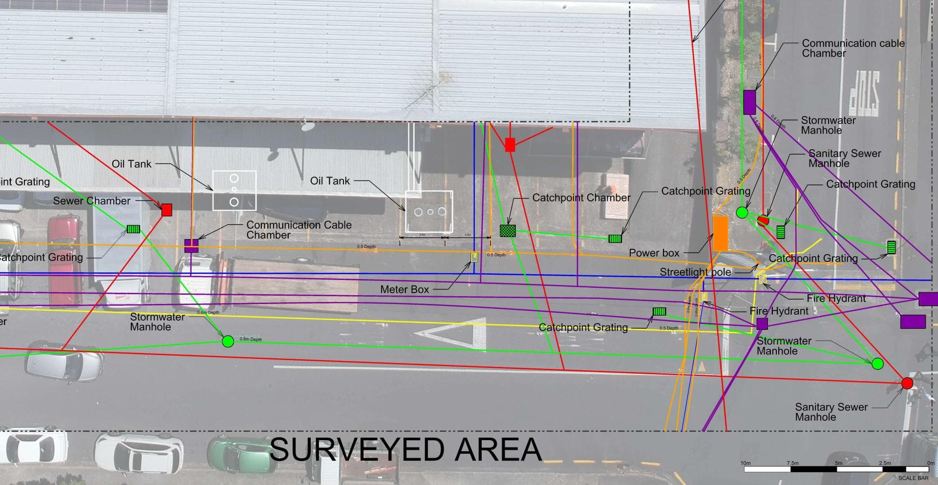
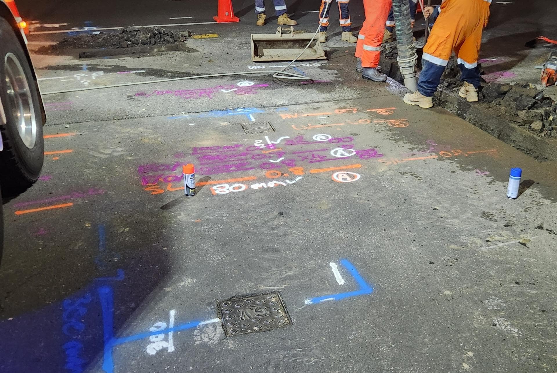
Digging anywhere in South Auckland means digging into sixty years of layered services. The state-housing berms carry water, gas, power and copper from the 1950s and 60s with fibre and new townhouse connections cut in on top. Wiri and Manukau yards hold private fire mains, process pipe and heavy cable that beforeUdig plans never show. The volcanic ground at Māngere and Wiri and the fill over old quarries confuse locators, and the peat at Takanini swallows GPR. Utility Works requests the plans, locates and marks every service we can find, flags the unknowns, potholes with hydro-vac where the dig crosses a line, and records the result on a plan you can keep.
Typical underground service locating jobs in South Auckland
- Locating and marking services in congested state-housing berms before driveway cuts and new connections
- Mapping private networks across Wiri, Manukau and Māngere industrial sites before pavement and drainage work
- Tracing through basalt, scoria and quarry fill where electromagnetic locators struggle
- Potholing to prove depth beside Vector feeds and Watercare mains before directional drilling
Underground Service Locating, in short
Before anyone digs, we find what is already in the ground: power cables, water and gas pipes, fibre and copper ducts, stormwater and sewer. Electromagnetic locators, tracer equipment, sonde-fitted cameras and ground penetrating radar each pick up what the others cannot, and we mark every service with its depth. Asset owners’ plans from beforeUdig are the starting point; the mark-out shows where things actually are. Where a service must be seen, our hydro-vac truck potholes it without damage, and if the job then needs trenching or a repair the same crew carries on. We can also record what we find with survey-grade GPS for plans and consents.
Full details: Service Location, Detection & Mapping →Working underground in South Auckland
South Auckland was farmland until the Southern Motorway pushed through in the 1950s, and most of what is under its streets went in over the next thirty years. Ōtara's state housing started in 1958 and had 3,000 houses within a decade, central Māngere followed in 1962, Papakura, Manurewa and Takanini had grown into one built-up area by 1964, and Manukau's new city centre opened its mall in 1976. That is a lot of galvanised and asbestos-cement pipe wearing out together.
The ground changes quickly. Māngere, Wiri and Puhinui sit on the lava and scoria of the Auckland volcanic field, the Takanini and Papakura flats are drained peat and soft Tauranga Group clays with groundwater a metre down, and the harbour edge at Weymouth, Clendon and Conifer Grove is estuary margin. Each hides a leak differently, so we never assume the wet patch marks the pipe.
The work splits three ways. In the state-housing belt it is failed laterals, shared supplies on cross-leases and new townhouses tying into old mains. In Wiri, Manukau and the Māngere industrial blocks it is private networks under hardstand that no public plan covers. In Takanini, Drury and Ōpaheke it is greenfield subdivision, with up to 22,000 homes planned around Drury alone, where as-builts seldom match the ground. Watercare supplies all of it from the Hūnua dams and the Waikato, Vector carries the power to Papakura and Counties Energy beyond, and our Waiau Pa yard is 25 to 40 minutes away.
When South Auckland’s homes were built, and what went in with them
The age of a house tells us what pipe and cable to expect underneath it before we arrive.
Before 1960
Papakura (borough 1938) and Manurewa (borough 1937) were small railway towns, and Māngere Bridge had suburban streets from the 1870s. State housing began at Ōtara in 1958, chosen for the motorway and the Ōtāhuhu and Penrose factories.
1960s to 1980s
The bulk of South Auckland: central Māngere's state housing from 1962, Ōtara's 3,000 houses by 1968, Manurewa East and Weymouth through the 1970s, Conifer Grove from 1974, Clendon Park from 1979, and Manukau's planned centre around the 1976 mall.
1985 to 2000
Growth slowed after the 1980s closures. Clendon's shops opened in 1984 and its streets ran on toward Weymouth, Manukau Supa Centa came in 1998, and Papakura District replaced Papakura City in 1989.
Since 2000
Takanini doubled between 2013 and 2023 on former army and golf-course land, Papakura grew by a third between 2018 and 2023, and the 2019 Drury-Opāheke structure plan allows up to 22,000 homes on about 1,900 hectares.
What is buried under South Auckland’s sections
Three pipe generations sit side by side across South Auckland. The 1950s and 60s state houses in Ōtara, Māngere and Papakura got galvanised steel laterals off cast iron and asbestos-cement mains; the galvanised pipe is rusting through and pinholing under driveways, and the AC mains crack at the joints. Manurewa, Weymouth and Clendon's 1970s and 80s streets are the asbestos-cement and copper generation, with Dux Quest polybutylene inside the later houses.
Takanini, Drury and the Manukau rebuilds since 2000 are MDPE and PE100 with tracer wire, except that fast subdivision leaves as-builts that do not match the trench and landscapers break the fittings. The 1990s laterals in between, PVC and early alkathene with no tracer wire, are invisible to an electromagnetic locator. So the common South Auckland job is a section with a 1960s galvanised line into a 2010s townhouse, where we first find out what is actually there with GPR and a sonde.
What South Auckland’s mixed ground means for locating
North to south, South Auckland is volcanic field, then soft flats, then clay hills. Māngere Mountain, the Wiri lava flows and the Puhinui craters belong to the Auckland volcanic field and put basalt, scoria and tuff near the surface in Māngere, Wiri and parts of Ōtara. From Manurewa south the Takanini and Papakura flats are drained peat and pumiceous Tauranga Group clays up to 20 metres deep, with groundwater a metre down in summer and near the surface in winter. South of Papakura the land lifts onto clay, with old lava from Pukekiwiriki at Red Hill.
On the lava a leak drains away through rock and shows nowhere near the pipe, and the digger meets basalt. On the peat flats everything is wet already, so a damp lawn means little, trenches flood and slump, and GPR loses depth. On the clay hills water surfaces along the trench rather than above the break. The Papakura Stream floods in heavy rain and runs to the Manukau Harbour.
Who owns the cables and pipes in South Auckland
Which network a service belongs to decides who fixes it, who you call first and whose plans a beforeUdig request returns.
Water supply
Watercare supplies the region, mostly from the four Hūnua dams via the Ardmore plant east of Papakura, topped up from the Waikato plant at Tuakau. The point of supply is the meter outlet; the lateral to the house is yours.
Wastewater
Watercare runs the sewers. A few lifestyle blocks around Karaka, Ōpaheke and Drury are still on septic tanks; we locate the tank and field before digging there.
Electricity
Vector runs from Wellsford to Papakura and covers Māngere, Ōtara, Manukau and Manurewa. Counties Energy takes over on Papakura's southern fringe and runs to Mercer, so Drury, Karaka and Ōpaheke are usually Counties.
Gas
Vector's gas list includes Māngere, Manukau, Takanini, Papakura, Drury and Kingseat, so expect a gas main in most berms. We locate the pipe; anything to do with the gas itself is Vector's job.
Fibre and phone
Chorus built Auckland's UFB fibre and owns the copper under it. Vector Fibre's business-only network means a Wiri or Māngere industrial boundary may carry two fibre owners.
beforeUdig plans
A request returns Watercare, Vector (electricity, gas and fibre), Chorus and Spark, plus Counties Energy south of Papakura. Plans show presence, not position, and never private pipes.
Jobs we have done here
Recent work around South Auckland
In Tony's words, from the Utility Works Facebook page. Clients unnamed, as they are there.
“Superb day smashing out a fire hydrant installation at a South Auckland yard. Another quality job completed by the team.”
Underground Utility Installation · South AucklandTony Eggleton · October 2026
“The team has been busy this week in South Auckland on ground testing pits ahead of a major infrastructure upgrade: ten areas service detected, hydro-slotted as required and then carefully excavated with the digger. All completed safely and on schedule.”
Underground Service Locating · South AucklandTony Eggleton · August 2026
“Another quality water mains renewal completed for a South Auckland retirement village, right through to the final reinstatement, landscaping and clean down.”
Water Mains Replacement · South AucklandTony Eggleton · April 2026
“Another services detection and mapping project under way for a long-term client in South Auckland. Over 200 individual pipes, cables, ducts and drains tracked and traced so far, with more to go.”
Underground Service Locating · South AucklandTony Eggleton · July 2025
“Water mains replacement in South Auckland.”
Water Mains Replacement · South AucklandTony Eggleton · July 2023
One crew for South Auckland: find it, dig it, fix it.
South Auckland is 25 to 40 minutes from our yard at Waiau Pa, Papakura closest and Māngere furthest, so travel adds little to a quote
Get a free quoteNeed underground service locating in South Auckland? Call us for a free, no-obligation quote.
Free, no-obligation quote · Mon–Fri 7am–5pm · Auckland, Franklin & North Waikato
Google reviews
What customers say
“Prompt service & fair pricing. Tony and his team — sharp eye for detail and out of the box problem solving paired with a high standard of workmanship.”
Richard La Trobe · Google · October 2026
“Really happy with the work to install our underground services. Highly recommend.”
Sarah Walworth · Google · October 2026
“The only company we trust… reliable, cost effective, and honest service from A to Z. 100% confidence in this company.”
Darrel Assink · Google · September 2026
Our Projects
Tuakau, North Waikato
Services Detection & Mapping in Tuakau
A local power network provider in Pukekohe needed expert service detection and mapping. With multiple high-voltage cables traced and marked out, duct and drainage tracing, water mains tracing and multiple communications cables in the vicinity, the project required our specialist services and expertise.
Read the case study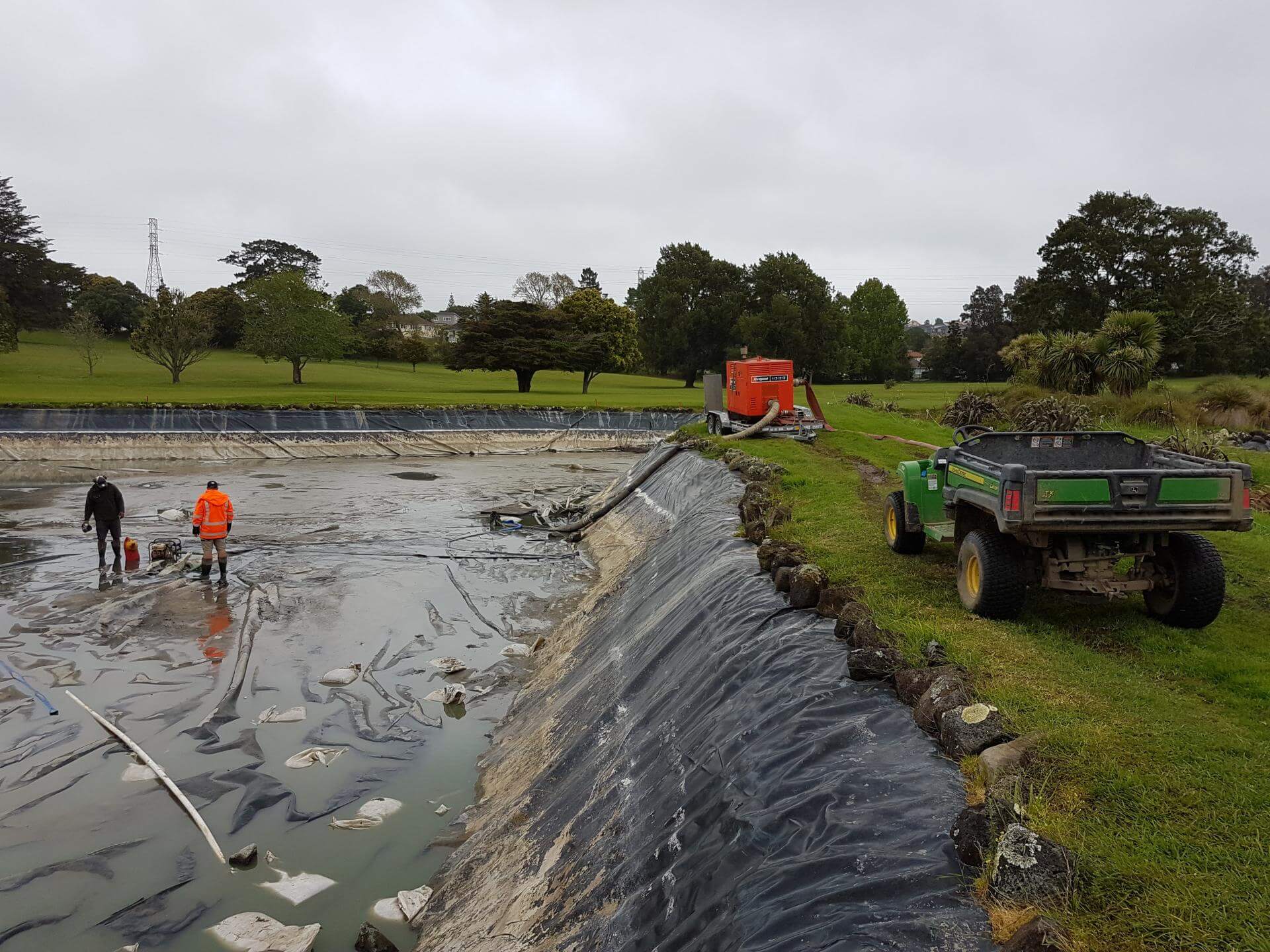
Auckland
Golf Course Pond Leak Detection in Auckland
Lined ponds pose many challenges once underground loss occurs. Utility Works was contracted to assist with the locating of pond leaks at a large Auckland golf course ahead of the dry summer months, when the irrigation system relied on the water supply. The process involved underwater diving and installation of pipe air bags to block the balance pipe and separate the two ponds, enabling accurate loss calculation, followed by GPR and IR works to determine likely areas of loss. The ponds were pumped out to enable locating of the defects for repair. We also assisted with the irrigation flow and isolation testing during the process.
Read the case studyUnderground Service Locating by suburb in South Auckland
Other services in South Auckland
Underground Service Locating in South Auckland: your questions
Do you cover all of South Auckland, or just Papakura?
Can you locate underground cables and pipes before I build a minor dwelling in Manurewa or Papakura?
Which lines company is my South Auckland property on, Vector or Counties Energy?
Ready when you are.
Tell us what you’re seeing or what you’re planning. You’ll get a straight answer, a free quote and one crew that does the whole job.
Mon–Fri 7am–5pm · Waiau Pa, South Auckland · Auckland, Franklin & North Waikato